Three Dimensional City Model (3DCM) is a 3D model based on 2D geographic information. Blender is a free and open-source 3D computer graphics software toolset for creating 3D-printed models, motion graphics, interactive 3D applications, virtual reality, and even the Metaverse.
Data Sources
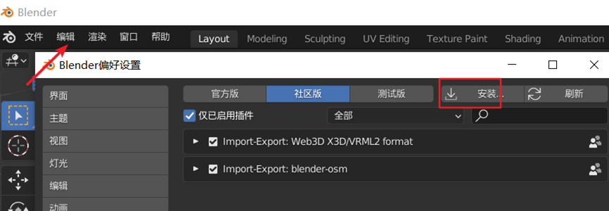
The data source is from Blender-OSM plug-in, which downloads from OpenStreetMap. Open the Blender software, click the plug-in bar in [Edit] -> [Preferences], and install the installation package downloaded from Blender-OSM.
Click here to download Blender-OSM
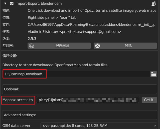
After the installation is complete, find the plug-in, open the drop-down settings, first select the save location of the map data on the local disk, then register on the MapBox and add AccessToken under the account information, copy and paste it into the MapBox access to text box of the plug-in.
Data Preprocessing
After the data source setting is completed, click the N key on the keyboard to find the osm plug-in, select the terrain, and select range to jump to the map page, where can freely choose the research area we need.
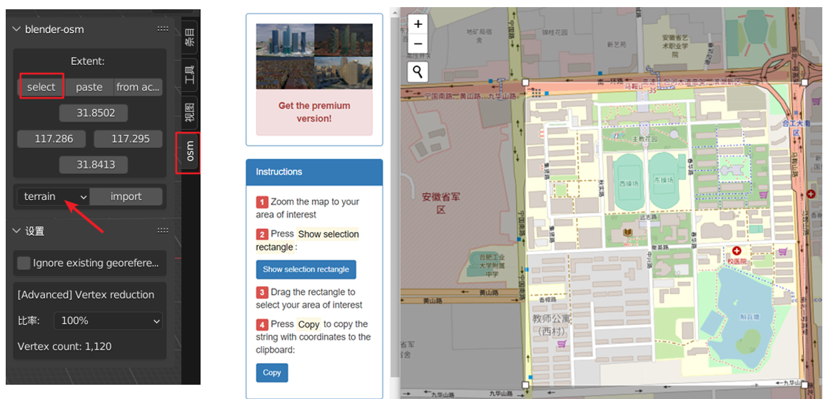
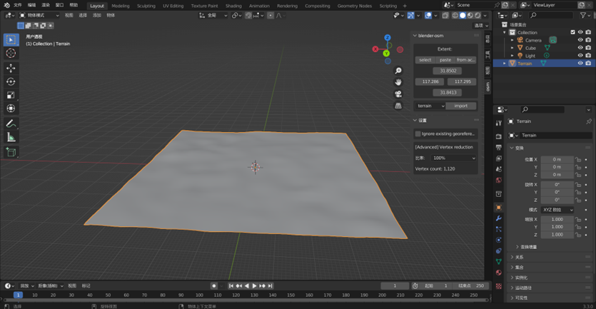
After the frame selection was completed, went back to Blender and pasted the scope of the selected area. Click Import, waiting for the terrain data of the research area to be downloaded.
Download the satellite image map on the ground and choose image overlay . As we use Mapbox's token in the plugin settings, so select Mapbox Satellite in the overlay column, and click Import to wait for the download to complete.
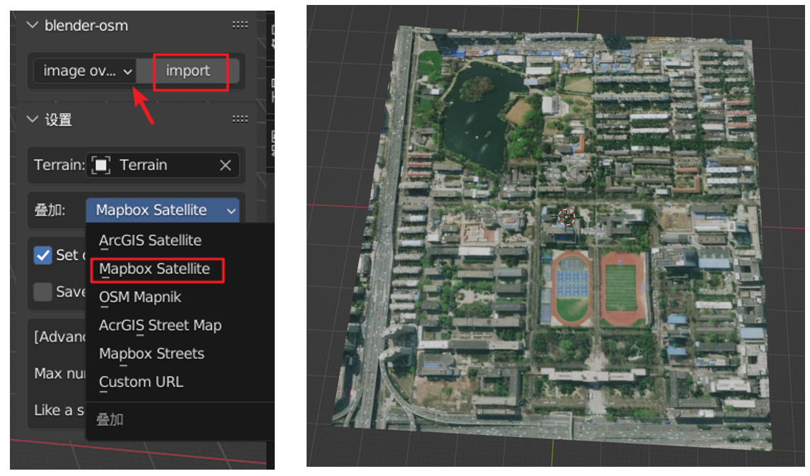
Model Establishment
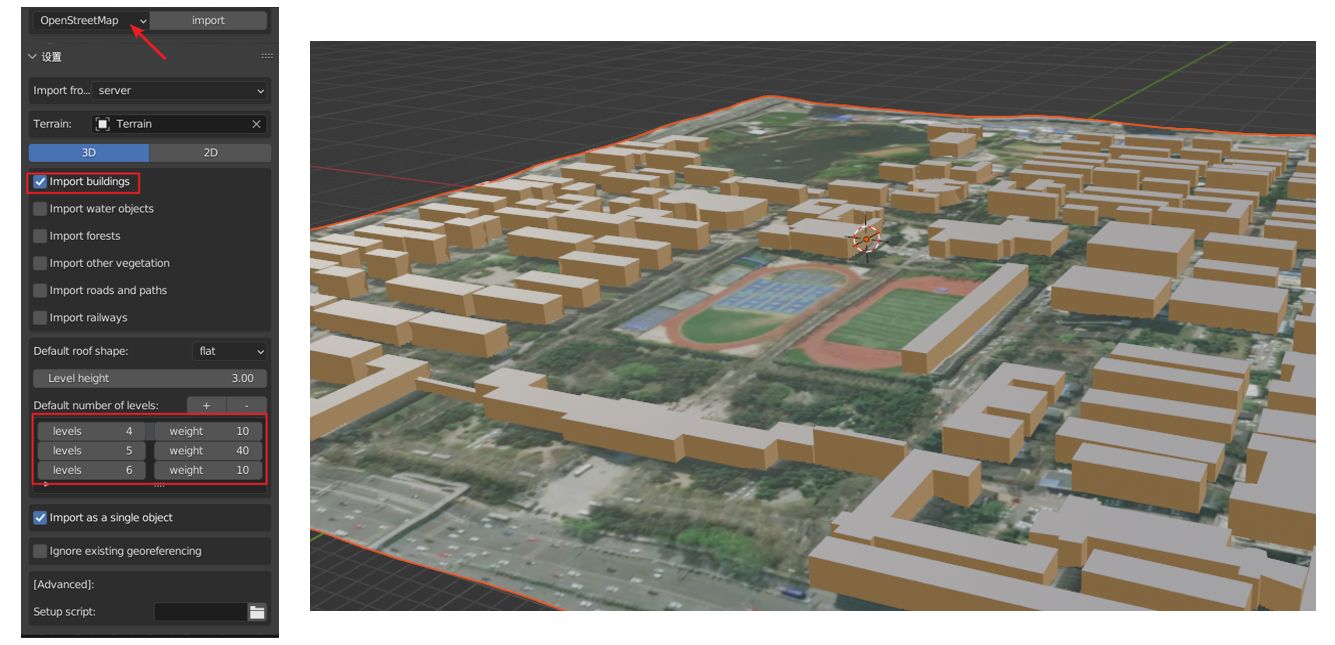
Select image buildings to download 3DCM and load the city building data.
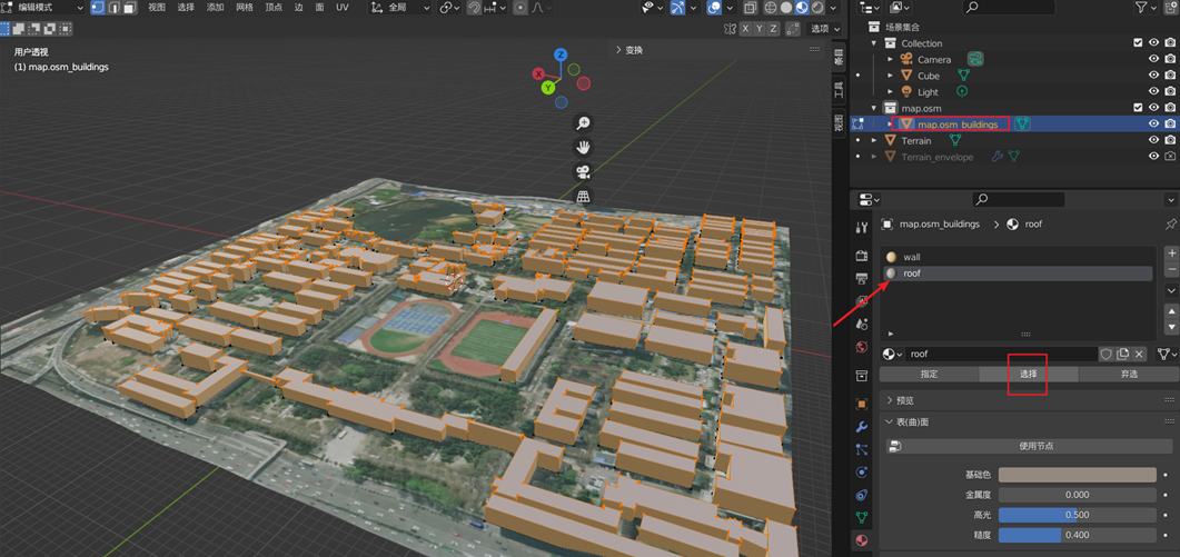
Select the building model in the scene, press the tab to enter the edit mode, click select, then press the Y and P to separate the roof, and press the tab to exit the edit mode.
Add Texture
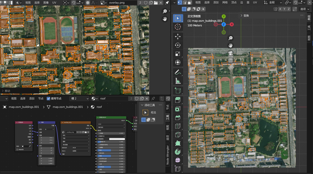
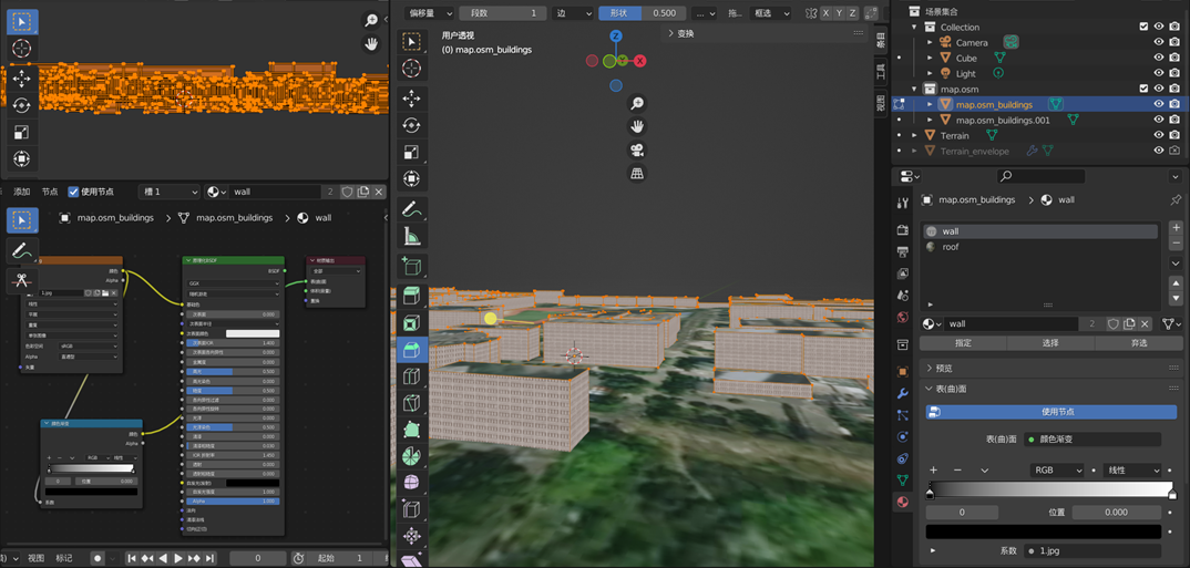
Open the shader editor in a new window, click the roof material node, select the BSDF, press and hold CTRL+T on the keyboard, add the downloaded satellite image), then create a new window, open the UV editor, and press the small button on the 3D view interface. Press keypad 7 to enter the top view angle and TAB to enter the edit mode, press the A to select all the building roofs, press the U to select the projection from the perspective, and use the S and G keys to adjust the position of the satellite map until it is aligned with the base map.
The same method is used to map the surface of the wall, add an image texture in the shader editor, import the architectural texture downloaded from the Internet. Then Adjust the size of the rectangle through UV projection - Block Projection to make the texture fit more entirely to the building wall.
Summary
With the continuous development of GIS technology, 3D GIS has become one of the development directions of the current industry. The powerful functions and uses of 3D GIS are not only to provide data for the development of digital cities but also to be used in urban analysis applications, such as in urban planning, architectural Construction, public safety management, urban emergency command, community service, and medical care all play a very important role.
16 comments
华纳圣淘沙公司开户新手教程
零基础学会(183-8890-9465薇-STS5099)
华纳圣淘沙公司开户
华纳圣淘沙公司开户保姆级教程(183-8890-9465薇-STS5099)
一步步教你开通华纳圣淘沙公司账户(183-8890-9465薇-STS5099)
华纳圣淘沙公司开户分步图解
首次开户必看:(183-8890-9465薇-STS5099)
华纳圣淘沙全攻略
华纳圣淘沙公司开户实操手册(183-8890-9465薇-STS5099)
华纳圣淘沙开户流程视频教程
手把手教学:(183-8890-9465薇-STS5099)
华纳圣淘沙公司开户
华纳圣淘沙公司开户完全指南(183-8890-9465薇-STS5099)
华纳圣淘沙开户步骤详解(183-8890-9465—?薇-STS5099【6011643】
华纳圣淘沙公司开户流程全解析(183-8890-9465—?薇-STS5099【6011643】
华纳圣淘沙公司账户注册指南(183-8890-9465—?薇-STS5099【6011643】
新手如何开通华纳圣淘沙公司账户(183-8890-9465—?薇-STS5099【6011643】
华纳圣淘沙企业开户标准流程(183-8890-9465—?薇-STS5099【6011643】
华纳圣淘沙公司开户:从零到一(183-8890-9465—?薇-STS5099【6011643】
官方指南:华纳圣淘沙公司开户流程(183-8890-9465—?薇-STS5099【6011643】
华纳圣淘沙公司开户流程说明书(183-8890-9465—?薇-STS5099【6011643】
果博东方客服开户联系方式【182-8836-2750—】?薇- cxs20250806】
果博东方公司客服电话联系方式【182-8836-2750—】?薇- cxs20250806】
果博东方开户流程【182-8836-2750—】?薇- cxs20250806】
果博东方客服怎么联系【182-8836-2750—】?薇- cxs20250806】
华纳公司合作开户所需材料?电话号码15587291507 微信STS5099
华纳公司合作开户所需材料?电话号码15587291507 微信STS5099
华纳公司合作开户所需材料?电话号码15587291507 微信STS5099
华纳公司合作开户所需材料?电话号码15587291507 微信STS5099
华纳公司合作开户所需材料?电话号码15587291507 微信STS5099
华纳公司合作开户所需材料?电话号码15587291507 微信STS5099
华纳公司合作开户所需材料?电话号码15587291507 微信STS5099
华纳公司合作开户所需材料?电话号码15587291507 微信STS5099
2025年10月新盘 做第一批吃螃蟹的人coinsrore.com
新车新盘 嘎嘎稳 嘎嘎靠谱coinsrore.com
新车首发,新的一年,只带想赚米的人coinsrore.com
新盘 上车集合 留下 我要发发 立马进裙coinsrore.com
做了几十年的项目 我总结了最好的一个盘(纯干货)coinsrore.com
新车上路,只带前10个人coinsrore.com
新盘首开 新盘首开 征召客户!!!coinsrore.com
新项目准备上线,寻找志同道合 的合作伙伴coinsrore.com
新车即将上线 真正的项目,期待你的参与coinsrore.com
新盘新项目,不再等待,现在就是最佳上车机会!coinsrore.com
新盘新盘 这个月刚上新盘 新车第一个吃螃蟹!coinsrore.com
新车上路,只带前10个人coinsrore.com
这篇文章如同一幅色彩斑斓的画卷,每一笔都充满了独特的创意。
作者的情感表达细腻入微,让人在阅读中找到了心灵的慰藉。
建议补充发展中国家案例,避免视角局限。
文章的确不错啊https://www.cscnn.com/
不错不错,我喜欢看 www.jiwenlaw.com
怎么收藏这篇文章?
叼茂SEO.bfbikes.com
博主真是太厉害了!!!
陈饪芙:文章真不错http://wap.jst-gpmx.cn/news/25312.html